
Tatsamenie Gold Camp
Carlin Gold and Stratabound Rare Earths, NW B.C.
Introduction
The Tatsamenie Gold Camp is located within the Golden Triangle of Northwest B.C. These claims cover intensely altered limestone and a varied suite of intrusions. The property is contiguous with the past-producing Golden Bear mine where six Carlin-type gold deposits have been defined with ore bodies averaging up to 20.5 g/t gold (Au).
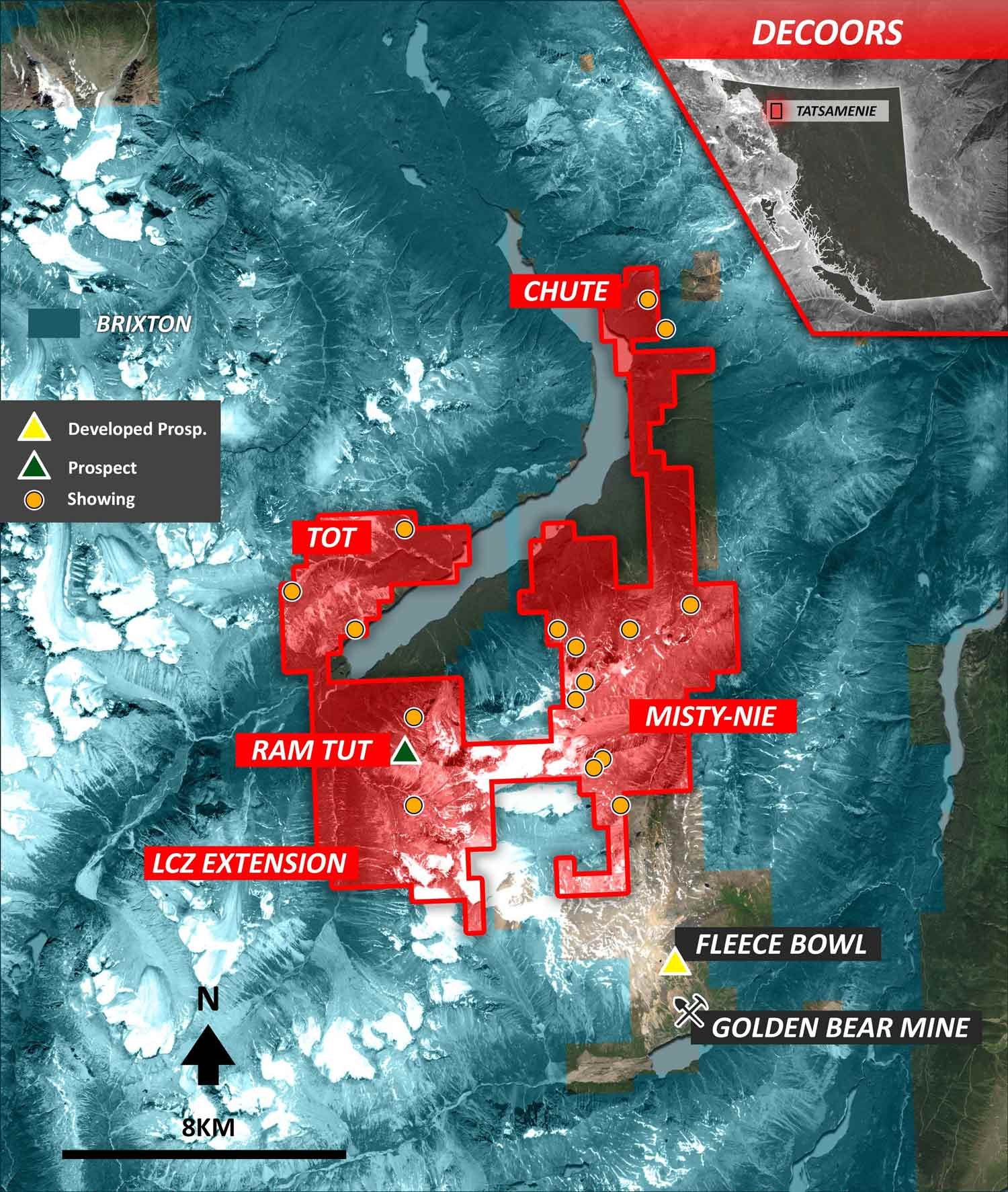
Tatsamenie Property Map
Golden Bear Mine History
The Golden Bear was mined from 1990-2001. More than $120 million worth of infrastructure (including road building costs) has been spent on the project. Approximately 220,000 ounces of gold were mined by Chevron Minerals and Homestake Mining (parent company of North American Metals). Wheaton River Minerals Ltd. later transformed it into British Columbia's first heap leach operation and mined an additional 265,000 ounces of gold from the Fleecebowl (Kodiak) and Ursa deposits.
The Golden Bear was in production when the price of gold was approximately $400/oz. At that time, exploration programs were heavily influenced by what operators could achieve economically given the current gold price. As a result, exploration programs primarily focused on areas in the immediate vicinity of the Golden Bear.
Work north of the Ursa deposit was somewhat limited due to logistical constraints. Any discovery made north of the Sam Creek ravine would have required the construction of a new road and mill. Consequently, the efforts and resources were concentrated where they could generate the most value.
"Wheaton's original feasibility study in 1995 estimated the mine would produce 215,000 ounces of gold at a production cost of US$233 per ounce. In fact, the mine produced more than 265,000 ounces at a cash cost of approximately US$170 per ounce, giving the company about $43 million cash flow during a time of record low gold prices. Production at Golden Bear peaked in 2000 at 94,000 ounces.” (Wheaton River Minerals Ltd. Press Release, September 7, 2001)
The mineralization at Golden Bear is disseminated gold developed in dilatant zones within high angle reverse faults. This fault system, known as the Ophir Break, continues north from the Golden Bear mine through the eastern half of the Tatsamenie property. Gold showings are located along its length. A second fault, the Limestone Creek Fault, is located a couple of kilometers to the west.
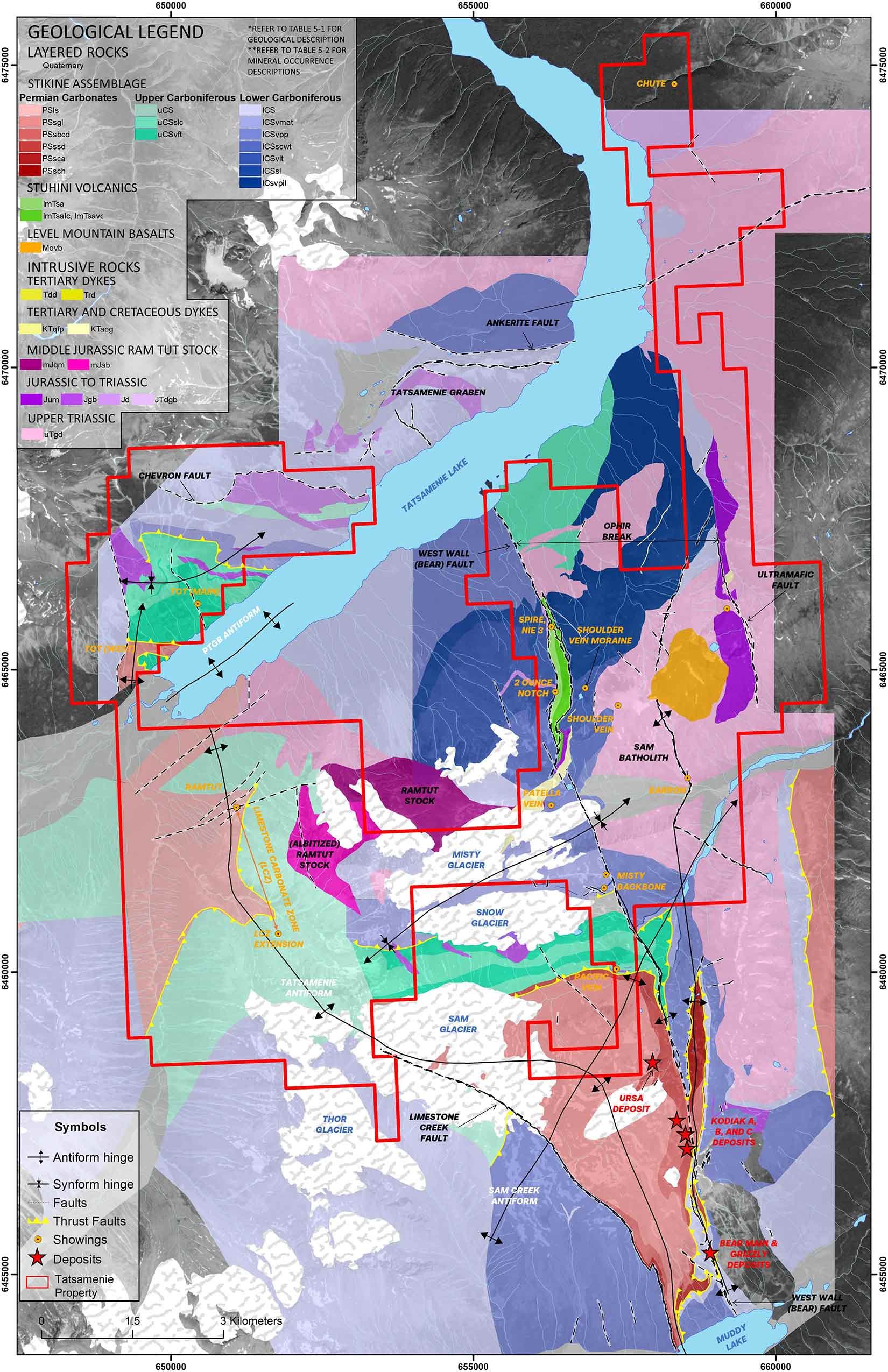
Tatsamenie Lake Area Geology
The Ophir Break and its related splays are the primary structural control for the Golden Bear deposits. The break is an economically important fault deformation zone that extends at least 15km from Bearskin Lake to Tatsamenie Lake. A thick sequence of Permian carbonates lies west of the Ophir Break and Stuhini volcanics predominate east of the deformation zone. The Ophir Break Zone is bounded on the west by the West Wall fault and on the east by the Ultramafic fault. After the Bear Main Zone was mined out in 1994, further exploration of the Ophir Break Zone by Wheaton River Minerals led to the discovery and mining of the Kodiak and Ursa deposits located to the immediate north.
The Limestone Creek Fault (LCF) was recognized as a blind fault in 1996. The LCF has received much less exploration due to till cover and glaciers masking the fault. The LCF is a northwest trending structure that has experienced more displacement than the Ophir Break. South of the Tatsamenie Property, a high-grade mineralized float train 100m wide x 500m long is located along the LCF. Drilling in the vicinity of the train intersected 2.93m of 1.83 g/t Au and 7.93 g/t Au over 4.57m.
“The discovery of gold in the LCF has a very significant impact on the exploration potential of the Golden Bear Property. Firstly, the LCF is a mirror image of the Ophir Break Fault with a configuration of a horst structure. Central to the horst is the carbonate lens with down dropped volcanics flanking the east and west. As such, the LCF is a fault panel of size equivalent to the 6 known deposits at Golden Bear. The successful holes drilled in 1996 are the first to intercept this structure.” (Property File 019958)
The Tatsamenie anticline is located north and along strike of the LCF. Southwest of Tatsamenie Lake, a 2 km long zone of silicification and brecciation (the “Limestone Carbonate Zone”, or LCZ) occurs within Permian carbonates along the projected strike of the LCF and Tatsamenie anticline.
An albitized Middle Jurassic stock (Ramtut) is located between the Ophir Break and LCF. This intrusion is depleted in rare earths. A strong rare earth MMI anomaly has been identified within limestone south of the LCZ to the west of this intrusion. This area, referred to as the LCZ Extension, is discussed in the Targets section below. Recent work by Barrick Gold on their Fourmile Carlin gold type deposit indicates that the Ramtut intrusion is an important exploration target. At Fourmile, Barrick chased structures north from their Goldrush deposit (10 Moz Au) toward the more metamorphic and metasomatic altered domain of the Middle Jurassic Milly Canyon stock. Drilling from 2015 – 2021 has developed an indicated resource of 0.35 Moz at 10.9 g/t Au and an inferred resource of 2.2 Moz at 10.6 g/t Au within a mineralized footprint of 500m x 100m. The drilling has produced exceptional grades, including hole FM19-46 which contained 26m of 80.9 g/t and 29m of 54.6 g/t Au.
Tatsamenie Exploration Targets
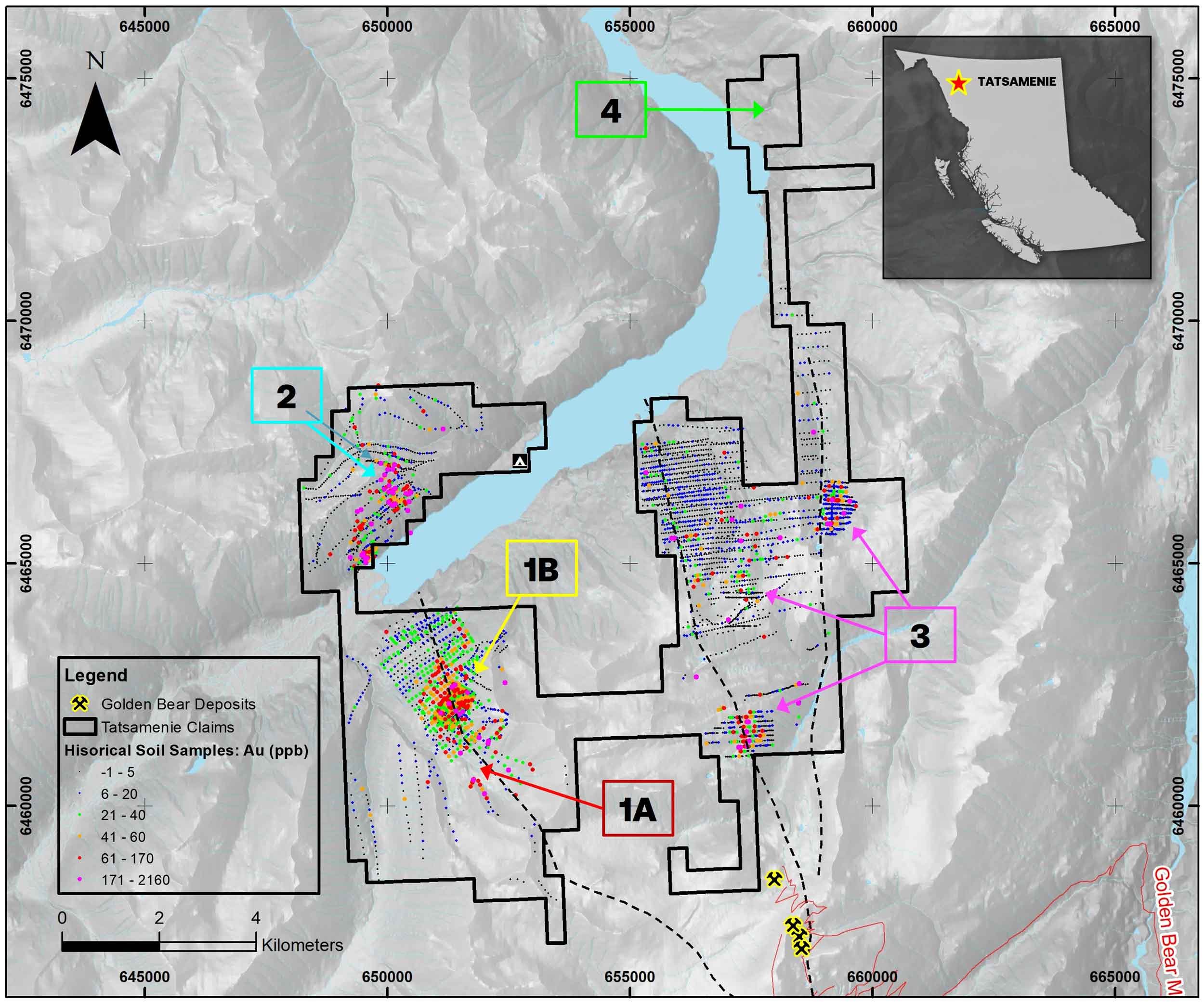 Tatsamenie Soils Map (Au - ppb) with targets
Limestone Carbonate Zone (LCZ)
The LCZ is a 2km long silicified zone that occurs along a limestone-phyllite contact adjacent to the Tatsamenie antiform. Chevron Minerals located the LCZ after regional bulk sediment samples draining the area returned values up to 18800 ppb Au. Follow up soil sampling surveys identified a 900m x 400m multi-element (gold, silver, arsenic, and antimony) soil anomaly containing >50 ppb Au. 8 holes have been drilled to test the LCZ. Values returned include 1.38 g/t Au over 4.76 m and 2.10 g/t Au over 1.75m. LCZ drill core is also enriched in several other metals:
Au – 2.38 g/t | Ag – 265.0 g/t
Bi – 15 ppm | Cu – 2939 ppm
Pb – >10,000 ppm | Zn – >10,000 ppm
As – 73,430 ppm | Mo – 148 ppm
Ni – 1150 ppm | Co – 173 ppm
Sb – 100 ppm | La – 100 ppm
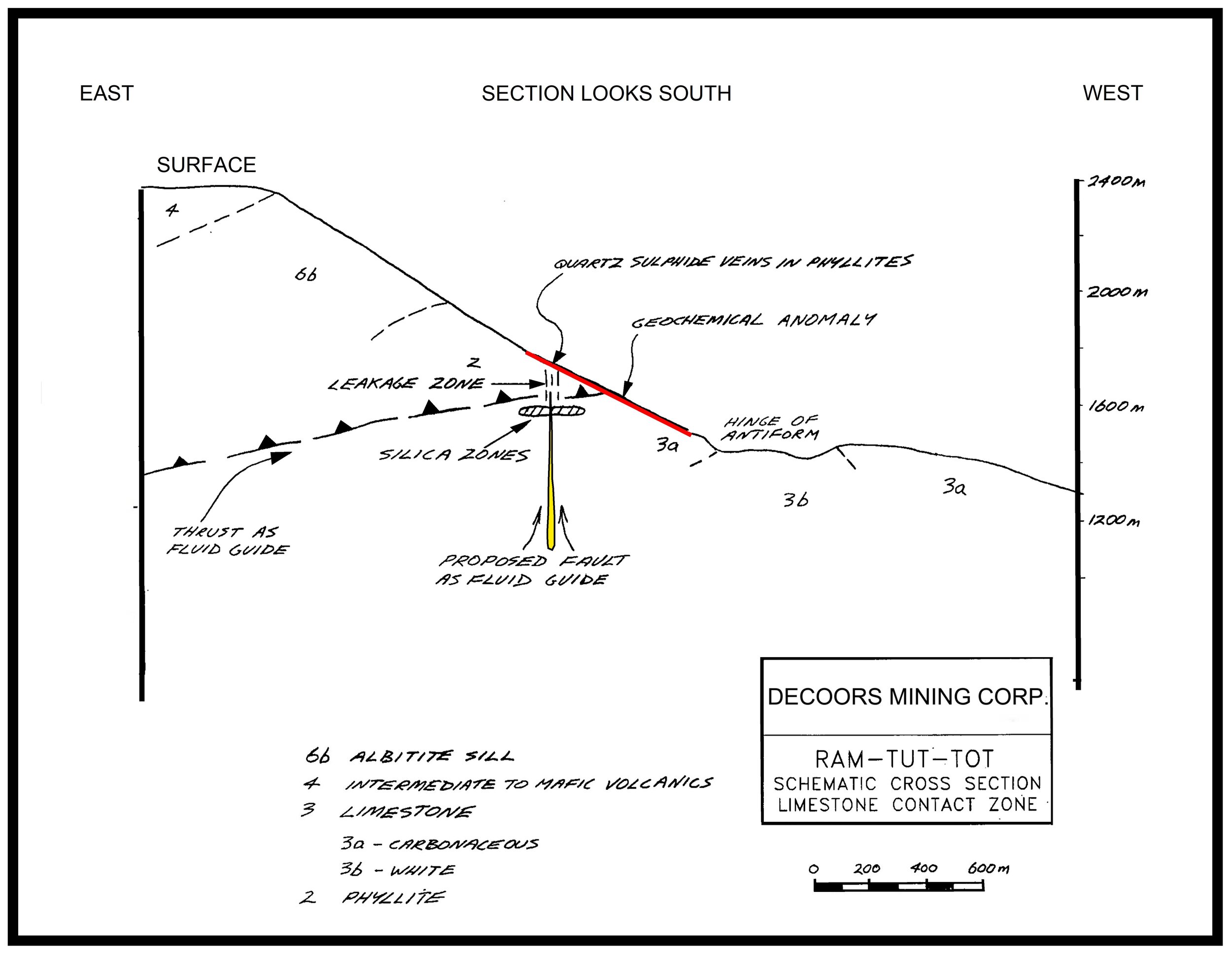
Chevron proposed that a Carbonate Replacement Deposit (CRD) or polymetallic manto may underlie the LCZ (see figure below). In this model where hydrothermal fluids have come up along a fault (a feeder) in the limestone unit and ponded below the phyllite unit. As drilling progressed south an increase in the thickness of the silicified zone was encountered. This was interpreted as getting closer to the feeder zone.
Limestone Carbonate Zone Extension (LCZ Extension)
Recent exploration has focused on an area 1 km to the south of the LCZ drilling. This area is referred to as the LCZ Extension. At the LCZ Extension silicified limestone outcrops with overlying phyllites containing silicified shears and limestone lenses. The LCZ Extension sits adjacent to the projected intersection of the Tatsamenie Antiform and a thrust fault in a cirque with little outcrop exposure.
Decoors Mining Corp. and Geotronics carried out a mobile metal ion (MMI) survey over this area in 2007. The survey targeted an area where Chevron had a single short contour soil line (of 19 samples at 10m spacing) return 7 values between 70-225 ppb Au.
The results from the LCZ Extension MMI grid contain the largest response ratios in 24 years of global MMI surveys. The MMI survey is anomalous in gold, silver, copper, lead, zinc, arsenic, cadmium, mercury, antimony, and rare earth elements (REEs). Two main areas of response occur within the grid. The Northwest Anomaly is a northwest-trending, multi-sample linear anomaly consisting of high-contrast responses for Au-Ag-Ag-Pb-Zn-Cd-Sb-Rare Earths. It extends to the limits of sampling and is open, striking towards Chevron’s Ram-Tut target. The East Anomaly is a smaller multi-element anomaly that remains open to the north and the east. The MMI results commonly include response ratios >50x background, highlighted by samples up to:
Au – 3580 ppb (7562x background)
Ag – 78400 ppb (6890x background)
As – 11400 ppb (1073x background)
Cu – 15800 ppb (129x background)
Pb – 53800 ppb (4894x background)
Zn – 26300 ppb (325x background)
Cd – 899 ppb (230x background)
Sb – 106 ppb (213x background)
Tot
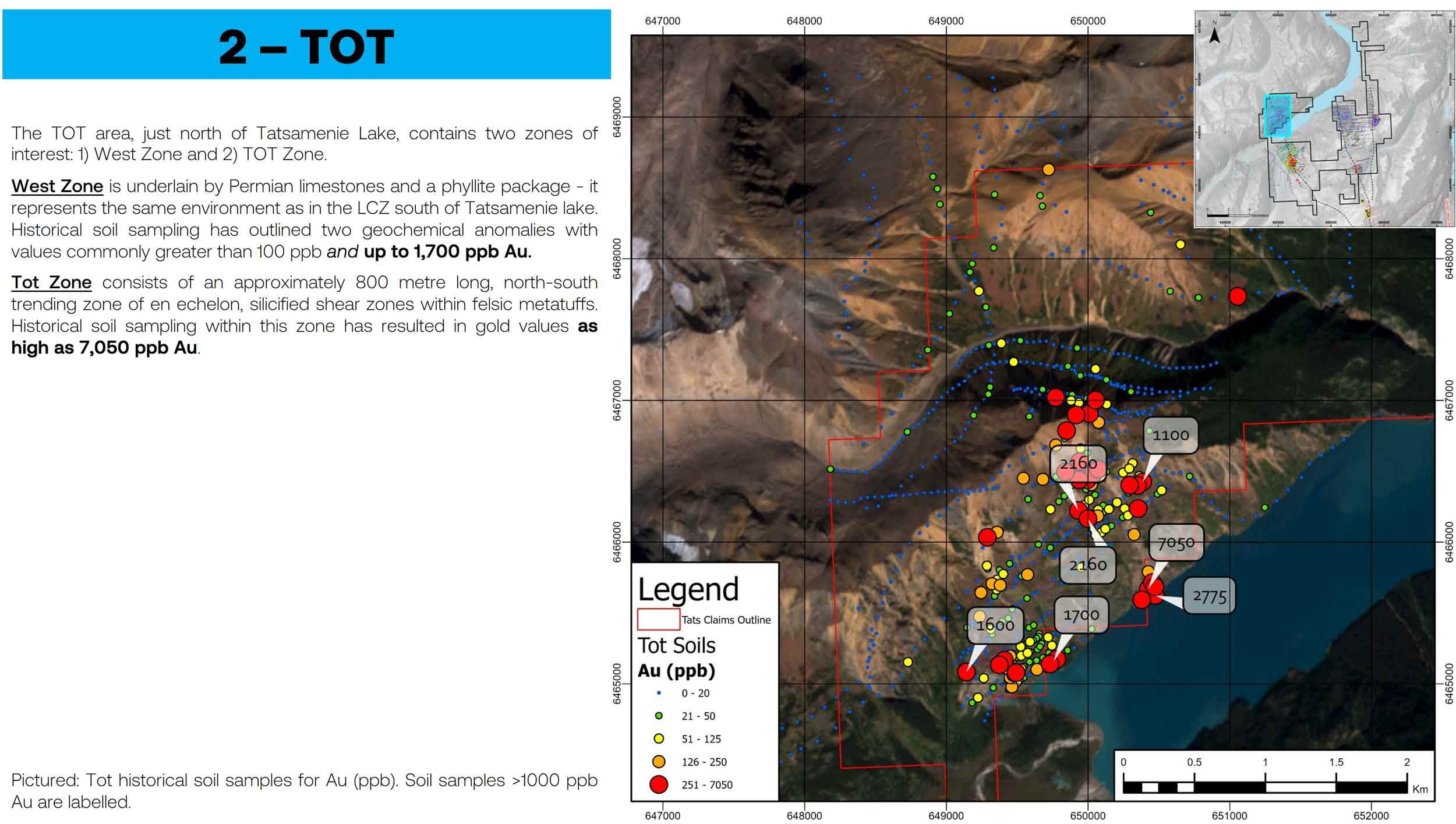
The Tot area, north of Tatsamenie Lake, contains two zones of interest. The Tot Zone consists of an approximately 800m long, north-south trending zone of en echelon, silicified shear zones within felsic metatuffs. The Tot West Zone is underlain by Permian limestones and a phyllite package - the same environment as in the LCZ south of Tatsamenie lake. At Tot, historical soil samples have returned up to 7050 ppb Au, several rock samples have returned 2 - 5.3 g/t Au, and 2 hand trenches have returned 3.92 g/t Au over 2.42m and 4.5 g/t Au over 2.0m.
The Tot has been tested with one drill hole. Drilling returned shallow intercepts of 2.5 g/t Au over 3.05m and 3.80 g/t over 2.26m along with four deeper 1-1.5m intersections containing >1 g/t Au.
Misty-Nie
The Misty-Nie area covers the extension of the West Wall and Ultramafic Faults where gold in silt, soil, and rock anomalies extend north of the Golden Bear Zone. Chevron drilled 30 shallow holes on the Misty-Nie in an effort to trace the West Wall fault. Several of these were drilled to depths of <5m. data-preserve-html-node="true" The most anomalous intersections were as follows:
Au - 1.2 g/t | Ag - 275.0 g/t
As - >10,000 ppm | Bi - 40 ppm
Cu - 1060 ppm | Mo - 1004 ppm
Pb - 8806 ppm | Zn - 3675 ppm
Sb - 400 ppm
The trace element geochemical signature from the core is comparable with the geochemical halo present around the gold deposits at the Golden Bear.
Targets within the Misty-Nie include the Backbone, Spire, and Ultramafic areas. The Backbone area hosts a 50m x 800m gold-in-soil anomaly along the West Wall Fault ranging from 100 to 325 ppb Au. Grab samples contain 9.8 g/t Au. The Spire area, located north of the Backbone, contains the “2 Oz. Notch” and Shoulder vein showings. Grab samples from the 2 Oz. Notch have returned up to 61 g/t Au. Grab samples from the Shoulder Vein have returned up to 124.8 g/t Au, 77.5 g/t Ag, and 4.17% Pb over 0.25m. The Ultramafic area contains the Ultramafic Vein in the eastern portion of the Misty-Nie area. Grab samples from the Ultramafic Vein have returned up to 18.1 g/t Au, 92.6 g/t Ag, and 0.87% Cu. Soil sampling north of the vein has identified 2 coincident Au-As anomalies. The larger soil anomaly, located 550m north of the vein, is 340m wide.
The Ultramafic Fault has never been drilled.
Summary
The style of mineralization on the Tatsamenie Property is similar to that of the Golden Bear Mine. Regional alteration and the strong hydrothermal system present are indicative of either a very large, or several smaller, systems. The size and extent of the system is conveyed by the widespread alteration (silicification) of the upper layers of limestone. The Ophir Break (West Wall + Ultramafic Faults) and LCF have been identified as feeder zones along which several styles of mineralization occur. There is a high potential for additional discoveries to be made within the claims. A major exploration program is warranted.
Deposit Models
Carlin-Type Gold Deposits
The best-known Carlin deposits are located along the Getchell, Independence, Carlin, and Battle Mountain Eureka trends in Nevada, U.S.A. Within these, gold deposits occur along feeder structures and open anticlines. Adjacent to the feeder the limestone is decalcified, silicified, and brecciated. Auriferous arsenian pyrite is a distinctive and unifying characteristic of these deposits (Simmons et. al., 2020).
The Ophir Break and LCF are two examples of feeder structures that share geological similarities with feeders associated with CTGDs in Nevada. Further exploration of these structures will focus on where they approach the metasomatically altered Middle Jurassic Ramtut stock.
Chevron's Proposed Deposit Model for the LCZ
Metasomatic iron oxide and alkali-calcic alteration (MIAC) systems are produced by fluid processes that chemically and mineralogically replace upper crustal rocks from depth to surface along regional fault zones. 30 of the 51 metals listed as critical by the Canadian, United States, European, Japan and Australian governments are economic and potential commodities in MIAC systems (Al, Ag, Au, As, Ba, Bi, Co, Cu, F, Mo, Nb, Ni, PGE (Pd, Pt), Rb, Re, REE (LREE, HREE and Y), Sb, Sc, Sn, Sr, Ta, Te, U, V, W, Zn and Zr in addition to non-critical Fe and Cd (Natural Resources Canada, 2021).
MIAC mineralization styles are diverse and consist of stratabound to discordant breccia zones, stockworks, veins, disseminations, replacement zones and mantos. Immediate ore hosts are intensely metasomatized by K-Fe alteration facies at high temperatures (magnetite, K-feldspar, biotite assemblages) and (or) at low temperature (hematite, K-feldspar, sericite, chlorite and carbonate-bearing assemblages). The ore and host alteration facies form within any host rocks, at any stratigraphic level, and commonly among units of different ages. Within a single system, deposits can be hosted in volcanic, sedimentary, intrusive, and metamorphic rocks (Corriveau et. al, 2022).
Within the Tatsamenie Property, the LCZ + LCZ Extension represent a MIAC stratabound replacement or polymetallic manto type target. Rare earths, depleted in the adjacent Middle Jurassic RamTut stock, may have been leached from the surrounding rocks and remobilized to this area during the same hydrothermal event that created the Golden Bear deposits. Trenching and drilling are required to test the anomalous zone.
Tatsamenie Property Presentations, Reports, and Theses
2023 Tatsamenie Assessment Report
2023 Barrick Gold Fourmile Presentation
1996 Thesis on the Tatsamenie Lake Area
1993 BCGS Open File on the Tatsamenie District Geology
1987 Preliminary Assessment of the Tatsamenie Lake Area with Special Reference to Proposed Roads
Tatsamenie Gallery

Tatsamenie Geology Map

Tatsamenie - Soil Samples (Au_ppb) and Target Areas

Tatsamenie East - Mineral Occurrences

Tatsamenie West - Mineral Occurrences

LCZ Extension - Rock Samples (Gold - g/t)

LCZ Extension - MMI Grid: Au_ppb

LCZ Extension: MMI Maps for Ag, As, Pb, Zn, Cd, and Sb

LCZ Extension: MMI Results - Rare Earth Anomaly
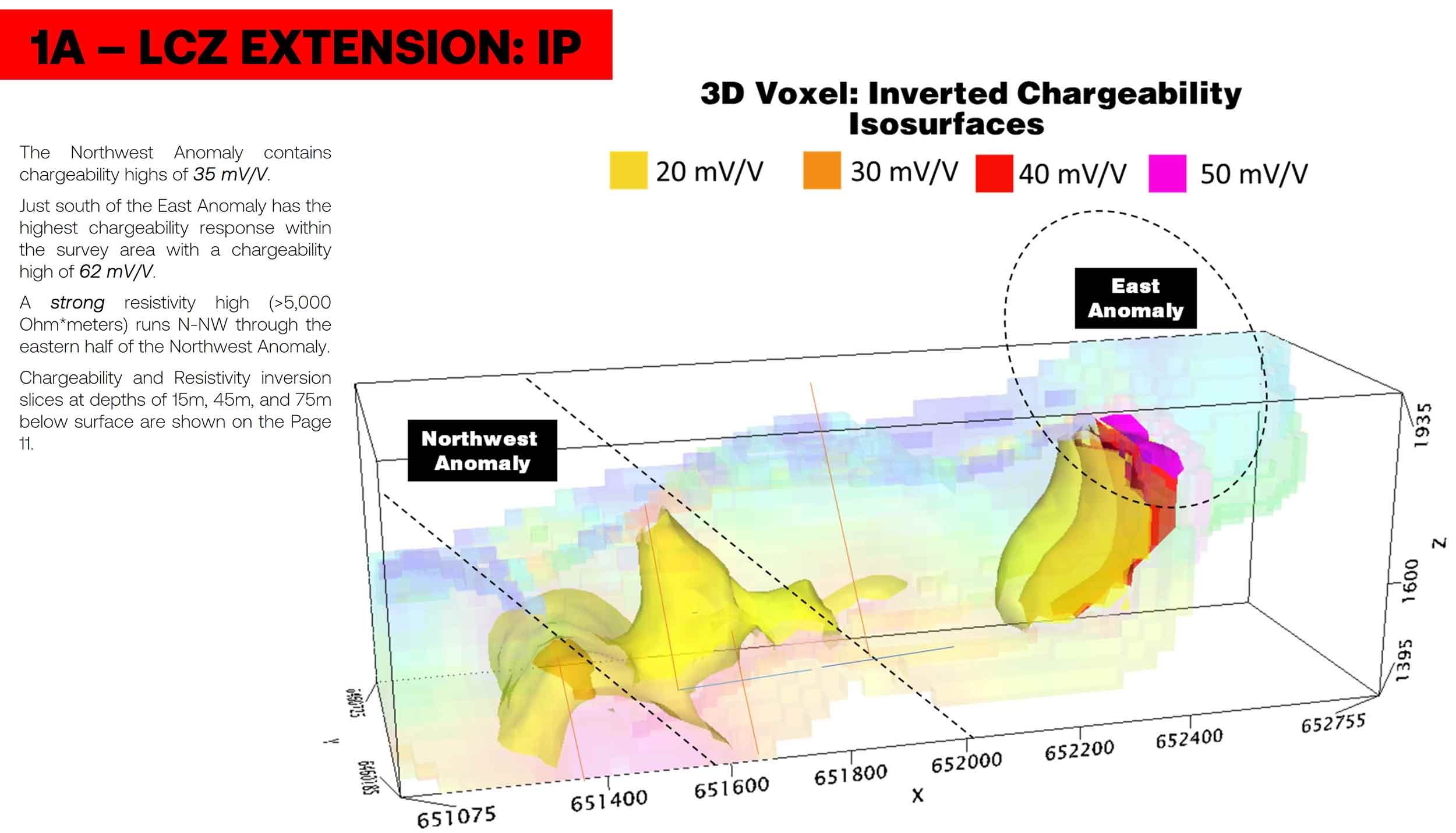
LCZ Extension - IP Chargeability Anomalies

LCZ Extension - IP Resistivity Anomalies
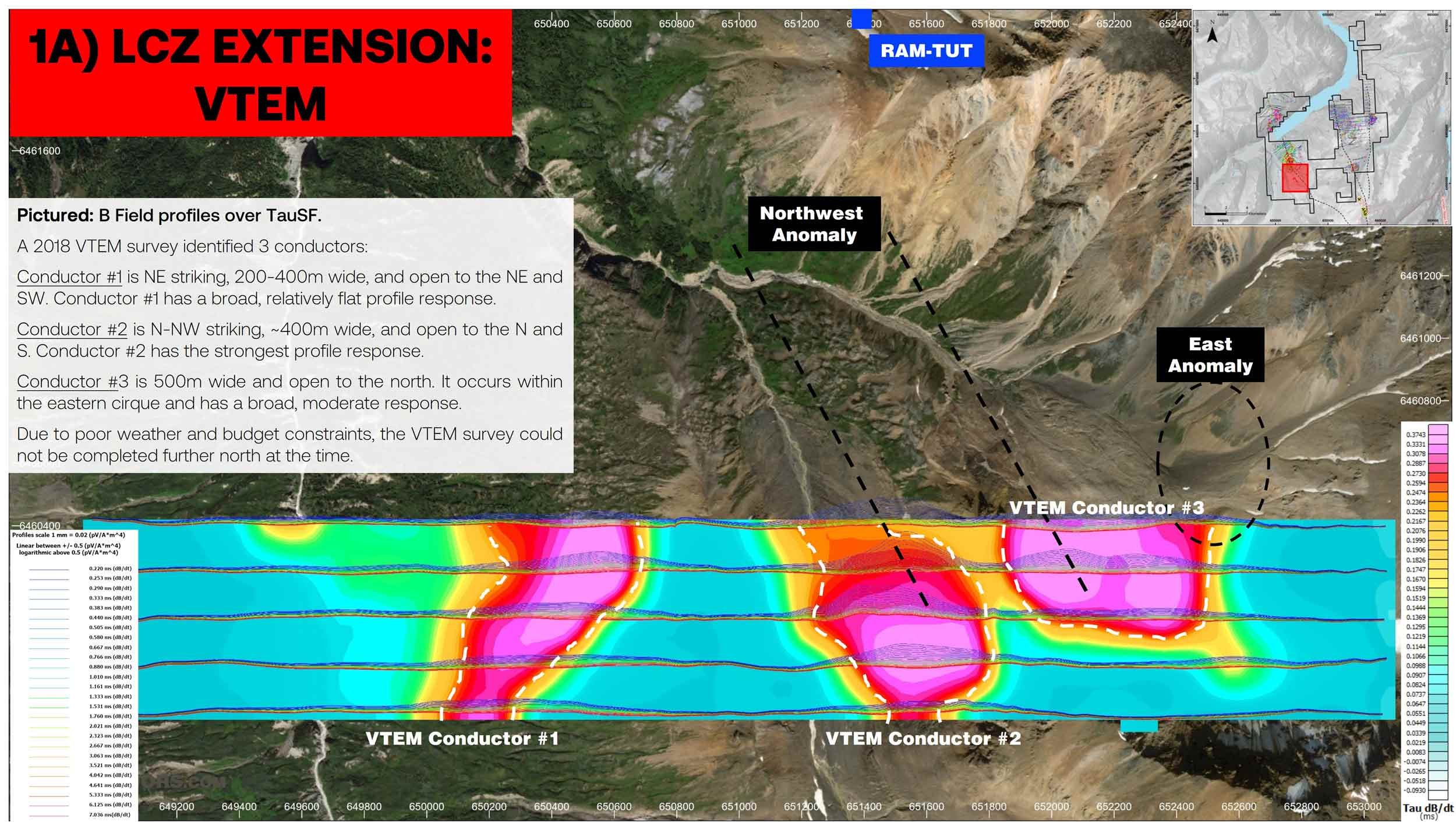
LCZ Extension - VTEM Anomalies

LCZ Extension - Anomalous Rock Samples (despite limited exposure)

LCZ Extension - Birds eye view looking south

LCZ - historical soil samples along the limestone carbonate zone north of the extension area. 900 m long >50 ppb Au anomaly.

LCZ - the same sample grid is anomalous for Ag, As, and Sb (the only elements analyzed for by Chevron)
Tot - north of Tatsamenie Lake and along strike of the LCZ. Soil samples up to 7,000 ppb Au.

Tot - Rock Samples: Au (g/t)

Misty-Nie: Historical soils - Au (ppb), Backbone area highlighted

Misty-Nie: Historical soils - Au (ppb), Spire area highlighted

Misty-Nie: Historical soils - Au (ppb), Ultramafic area highlighted

Camp and historical core still in racks.

Looking south from the Misty-Nie over the Sam Creek ravine towards the Golden Bear mine

Looking South from LCZ to LCZ Extension

Looking South at the LCZ Extension
Looking North from the LCZ Extension towards the LCZ

Looking North from the LCZ Extension towards the LCZ 2

Looking north from the LCZ Extension. Helicopter staging and fly camp area is at the flat bench below

LCZ Extension: Outcrop 1

LCZ Extension: Outcrop 1
LCZ Extension Rock Sample 1760
LCZ Extension Rock Sample 1760b
LCZ Extension Rock Sample 1761

LCZ Extension Rock Sample 1766