Titan
Porphyry and Polymetallic Vein Target, Atlin B.C.
Introduction
The Titan Property is located 35 km southwest of Atlin in northwest, B.C. These claims cover a portion of the Llewellyn Fault Zone (LFZ). The LFZ is a >150km long crustal-scale fault system which hosts numerous gold, silver, and base metal properties, including the Engineer Gold Mine. Exploration targets on the Titan property consist of polymetallic veins and a molybdenum porphyry occurrence.
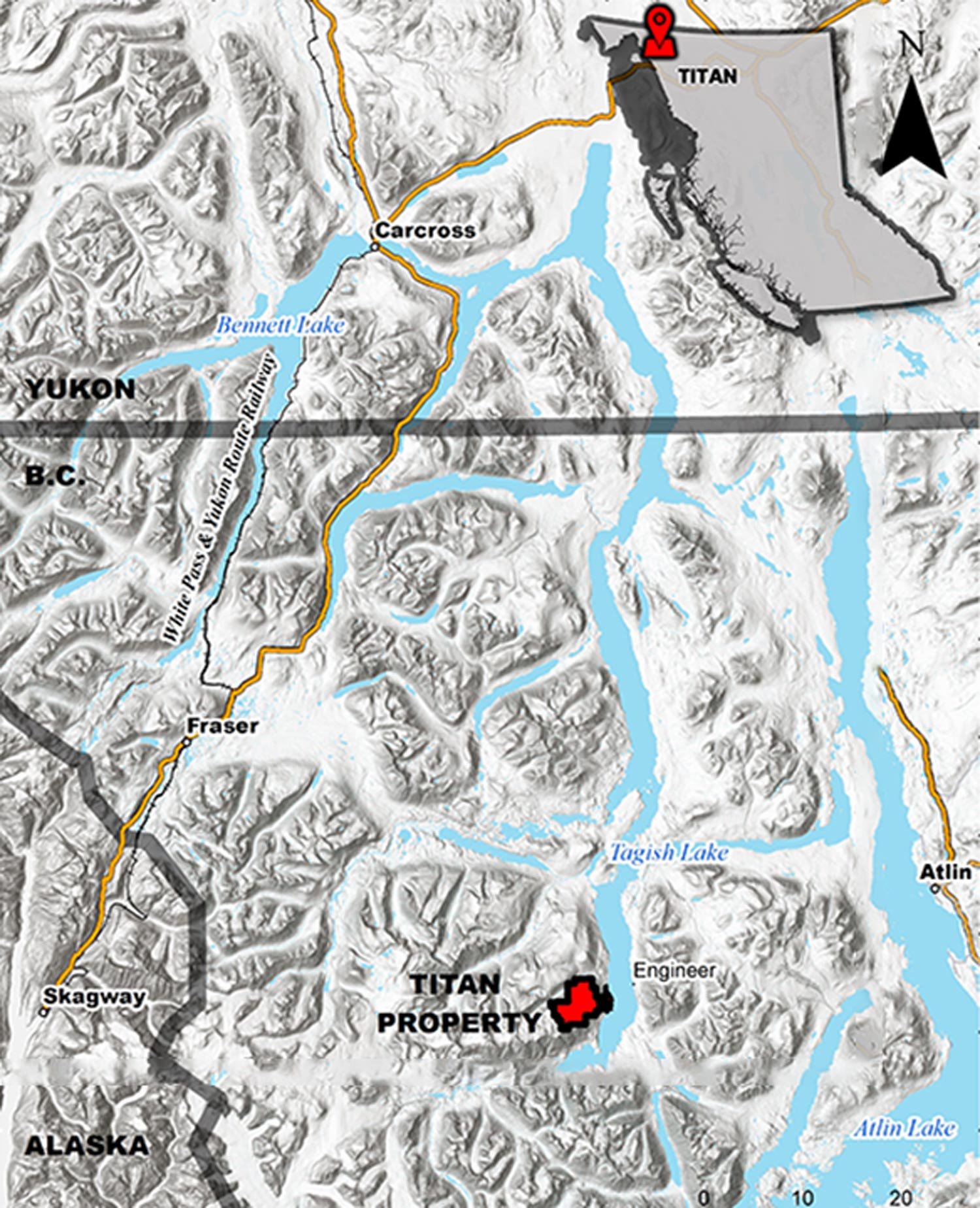
Titan Location Map
Exploration History
In 1899, the Rupert and White Moose polymetallic veins were discovered along the western shore of Tagish Lake's Taku Arm opposite the Engineer Mine. These were explored by trenches, adits, and shafts. In 1904, 840 kg of sorted ore from the White Moose quartz veins assayed 0.78 oz/t Au, 50.34 oz/t Ag, 7.36% Cu, 3,85% Zn, 4.79% Pb, and 1.37% Sb (Minister of Mines Annual Report, 1904). Additional exploration was carried out until 1918. During this time, mineral exploration was carried out only in the summer months because of high operating costs, cold temperatures, and limited winter access. As was the custom of the time, mining workers waited for the last boat out of Skagway before the close of the season. On October 25, 1918, the last boat, the SS Princess Sophia, sank after striking Vanderbilt Reef in the Alaska Panhandle. All 364 passengers and crew died. Captain James Alexander, owner of the Engineer Mine, and Charles E. Watson, manager of the Mining Corporation of Canada, were among them. With an economy stretched to the limit by World War I and a manpower shortage due to wartime enlistment, the loss of a large segment of the active mining community was irreplaceable. No further exploration took place within the Titan property until the 1970s.
From 1979 - 1990, United Keno Hill Mines Limited (UKHM) and Placer Dome explored the property. Although fieldwork was directed towards assessing gold-silver vein potential, field crews noted that the ongoing retreat of glacial ice at the headwaters of Buchan Creek had begun to expose porphyry copper – molybdenum mineralization.
In 2002, the Titan claims were staked by ex-UKHM geologist Dennis Ouellette after the company became insolvent. Rock samples collected from a glacially derived boulder field returned values of up to 0.8% Mo and confirmed the presence of high-grade molybdenum mineralization at the headwaters of Buchan Creek.
In 2003, Eagle Plains Resources optioned the Titan property. From 2003-2014, Eagle Plains conducted several work programs. These consisted of geological mapping, soil sampling, rock sampling, induced polarization, an airborne magnetic and radiometric survey, a SkyTEM survey, and drilling.
Decoors staked the property after it lapsed in 2018. We have since completed a comprehensive compilation of all historical data within the Property. This process included the digitization of 2014 soil samples, 305 rock samples, and 67 stream samples. Data from Eagle Plains' induced polarization and SkyTEM programs were was also acquired, processed, and reinterpreted.
Titan Exploration Targets
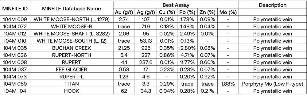
There are a total of 11 mineral showings within the claims. A summary of these is included in the table below.
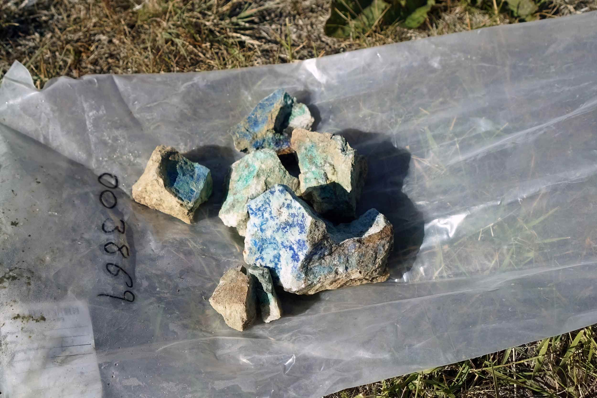
The compiled geochemistry highlights the exploration potential of the Titan property. Several sediments taken from streams draining the claims rank in the >98th percentile for gold, silver, copper, molybdenum, lead, and zinc within the regional BCGS Tagish Lake survey. Soil samples range up to 3200 ppb Au, 15.7 ppm Ag, 1372 ppm Cu, 3200 ppm Pb, 2400 ppm Zn, and 253.8 ppm Mo. Rock samples range up to 62 g/t Au, 1060 g/t Ag, 0.93% Cu, 1.877% Mo, 39.0% Pb, and 6.0% Zn.
Reinterpretation of the airborne geophysical results indicates that the Buchan Creek and Rupert showings occur along a north-northwest trending magnetic lineament. This suggests that these showings may be connected. This area has very encouraging mineralization potential. Reprocessing of the SkyTEM high moment Z coil data has identified a 750m x 500m circular conductive anomaly (Anomaly A, red circle on the Titan Satellite Map) approximately halfway between the Buchan Creek and Rupert showings. Anomaly A underlies a plateau that is covered by talus and reworked glacial moraine material mixed with talus fines, silt, and clay. This may explain why previous geochemical surveys over the area have returned low results while anomalous samples have been obtained near outcropping rocks present to the north and south.
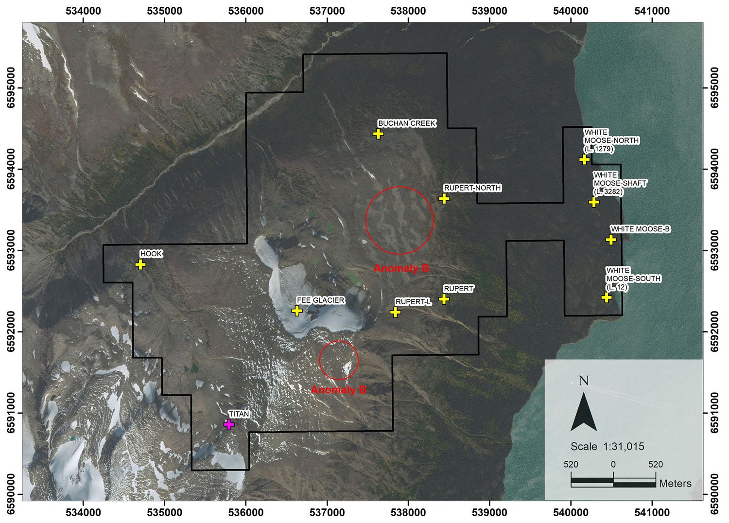
Titan Satellite Map with Targets
Next steps
A program of induced polarization is recommended to cover Anomaly A, the Buchans Creek, and Rupert showing areas.
Reports
Titan Gallery

Titan Geology Map

Titan Targets Overview Map

Titan Geochemistry: Gold

Titan Geochemistry: Silver

Titan Geochemistry: Copper

Titan Geochemistry: Molybdenum

Titan Geochemistry: Lead
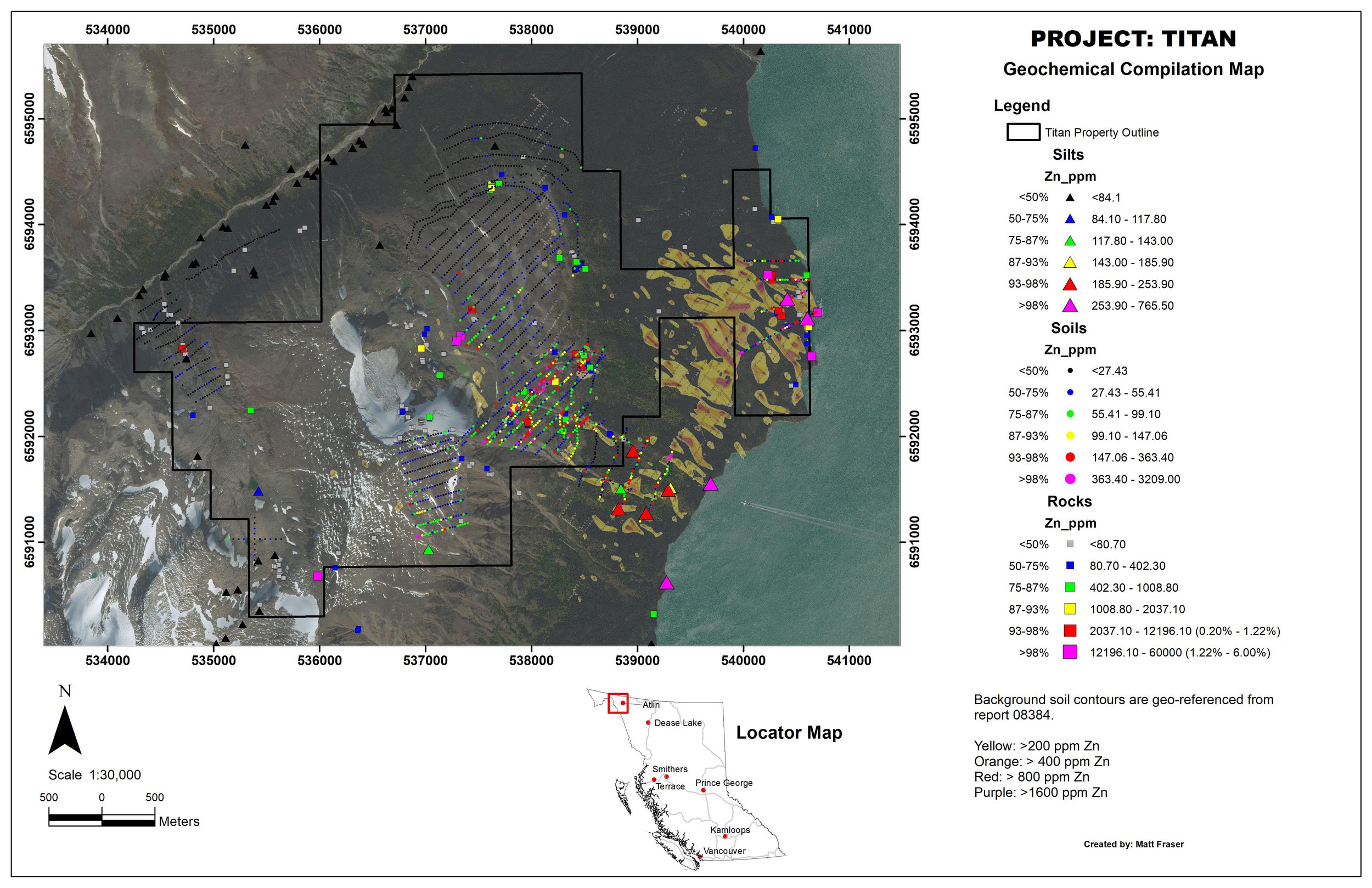
Titan Geochemistry: Zinc

Titan SkyTEM: Total Magnetics (TMI - nT)

Titan SkyTEM: Tilt Derivative (TDR- nT/m)

Titan SkyTEM: Conductivity - High Moment, Gate 21 (pV/(m4*a)

Titan SkyTEM: Resistivity